Heritage in South Asia
Explore heritage sites and cultural practices from South Asia.
Sites in this Region
Showing 9 documented sites

Adam's Peak (Sri Pada)
Adam's Peak — Sri Pada, the Sacred Footprint — is a 2,243-metre conical mountain in the Sri Lankan highlands whose summit rock formation is venerated as a sacred footprint by four of the world's major religions simultaneously. For over a thousand years, pilgrims of all these faiths have climbed 5,500 steps through the night to reach the same summit at the same dawn, making it one of the oldest continuously shared sacred sites in the world. The mountain's surrounding cloud forest is a biodiversity hotspot containing over 150 endemic plant species found nowhere else on earth.

Attirampakkam
A stratified sequence of stone tool assemblages spanning approximately 1.5 million years, from the earliest known Acheulean handaxe technology in peninsular India through a transition to Middle Palaeolithic technology that appears — according to radiometric dating published in 2018 — significantly earlier than the same transition in Africa and Europe, potentially before the dispersal of anatomically modern humans out of Africa and challenging fundamental assumptions about the cognitive and demographic history of early humans in South Asia.

Hampi
A 26-square-kilometre open landscape of approximately 550 monuments distributed across an extraordinary terrain of stacked granite boulders along the Tungabhadra River — once the capital of the Vijayanagara Empire, one of the wealthiest and most populous cities on earth in the fifteenth and sixteenth centuries. Temples, bazaars, royal pavilions, elephant stables, and sacred tanks appear across ridgelines and around corners in a landscape that feels less like a heritage site and more like a civilisation that forgot to fully disappear. Large sections remain in active religious use, as they have been for over a thousand years.

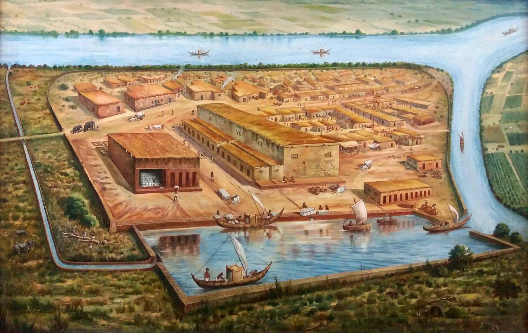
Harappa
One of the two great cities of the Indus Valley Civilisation, a Bronze Age urban culture that at its height was probably the most populous civilisation on earth, organised around a level of urban planning sophistication — standardised brick dimensions, grid streets, elaborate drainage systems — that remains remarkable even in comparison with much later achievements, and whose undeciphered script represents one of the outstanding unsolved problems of ancient linguistics.
Konkan Geoglyphs (Ratnagiri Rock Art)
The Konkan geoglyphs (locally called 'Petroglyphs' or 'Kurumd' by local communities) are a collection of more than 1,500 carved rock figures discovered across the laterite plateaus of the Konkan coastal region of Maharashtra between 2012 and 2018, representing one of the largest concentrations of prehistoric rock art in Asia. The figures — carved into the flat laterite rock surfaces of elevated plateaus ('sada' in Marathi) — include geometrically stylised animals (rhinoceros, hippopotamus, elephants, fish, turtles, sharks, deer, boar), humanoid figures, birds, and geometric forms. The engravings, estimated to date from 10,000 to 25,000 years BP, were created by pecking into the laterite surface with harder stone tools, producing line-pecked figures with varying degrees of completeness. The presence of hippopotamus and rhinoceros among the figures suggests the engravings predate regional megafaunal extinction in the Indian subcontinent, potentially placing them among the oldest surviving figurative rock art in South Asia.
Lothal
The southernmost major site of the Indus Valley Civilisation and home to what is widely considered the world's oldest known artificial dock — a tidal basin measuring 218 by 37 metres, lined with kiln-fired bricks, that demonstrates the maritime capabilities and long-distance trading reach of a Bronze Age civilisation four thousand years ago, now facing coastal erosion, sea level rise, and the dual pressure of inadequate conservation resources and a major new heritage complex development.
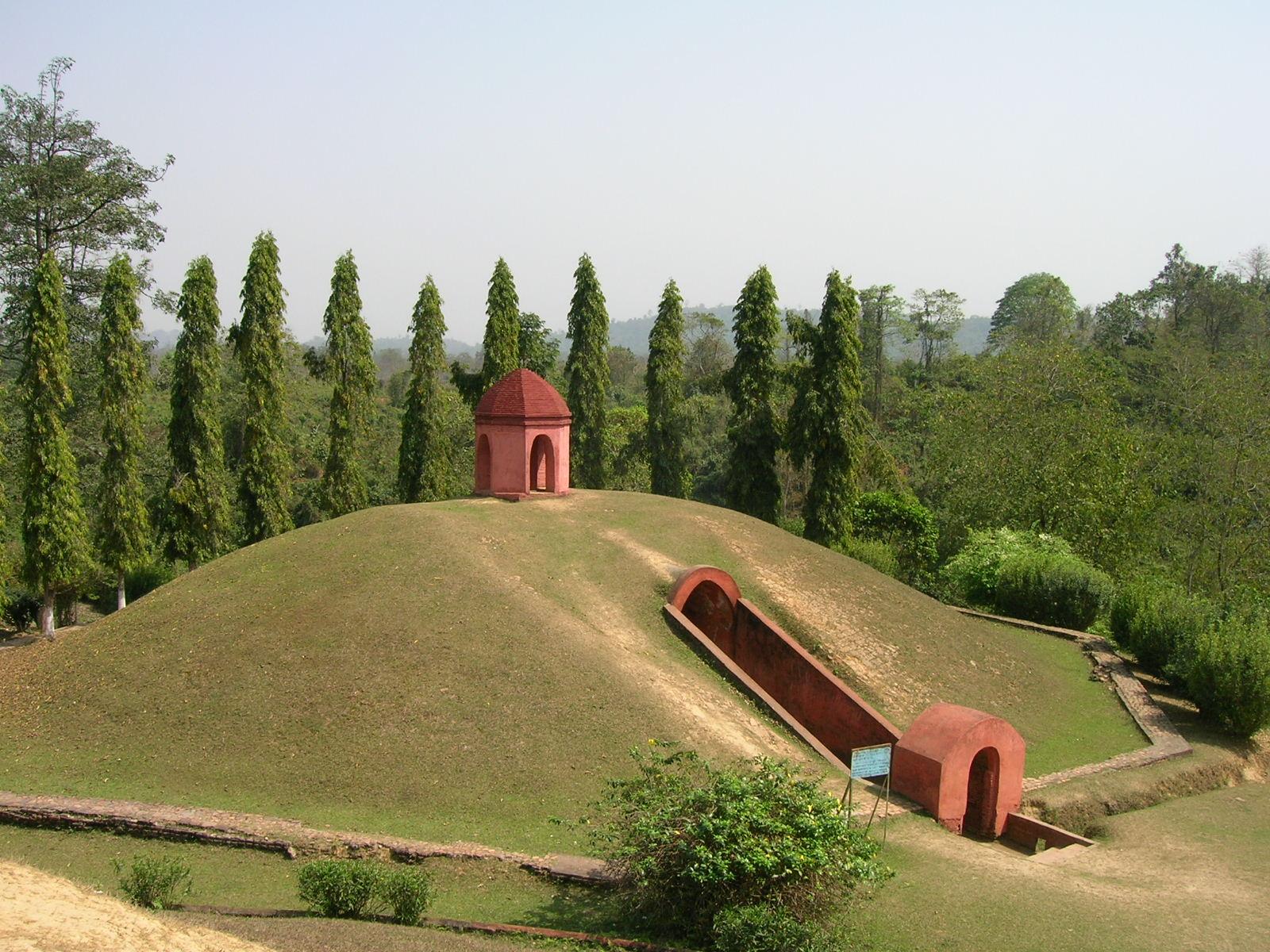
Moidams
Moidams (also spelled Maidam) are the burial mounds of the Ahom Kingdom — the Tai-Ahom dynasty that ruled Assam in northeast India for nearly 600 uninterrupted years (1228–1826 CE), one of the longest-ruling dynasties in Asian history. A moidam consists of an octagonal base structure enclosing one or more domed burial chambers (garh) of brick or stone, within which the Ahom king or noble was interred with grave goods — gold and silver artefacts, personal possessions, and food offerings — along with, in earlier periods, the servants and wives who accompanied the deceased into the afterlife. The burial chamber is then covered with an earthen mound of prescribed form and surrounded by a brick boundary wall and gateway. The Charaideo Moidam complex — the royal burial site of the Ahom kings — contains the moidams of thirty-plus Ahom monarchs and hundreds of their relatives and nobles, making it one of the most significant royal necropolis sites in South Asia.
Rock Shelters of Bhimbetka
The Rock Shelters of Bhimbetka in Madhya Pradesh contain the largest concentration of prehistoric rock art in India and one of the most significant in the world, with over 700 rock shelters across five clusters and approximately 500 bearing paintings spanning a period from the Mesolithic (approximately 30,000 years ago) through the early historical period. The same rock surfaces were painted and repainted across thousands of years by succeeding generations of people who lived in the shelters, creating a layered visual archive that is simultaneously the earliest known evidence of human presence on the Indian subcontinent and a record of cultural continuity across an extraordinary span of time.

Taj Mahal
The Taj Mahal is a mausoleum of white marble built between 1632 and 1653 by the Mughal Emperor Shah Jahan in memory of his wife Mumtaz Mahal, who died in childbirth. Widely considered the supreme expression of Mughal architecture, it is one of the most formally perfect buildings in the world. The marble is turning yellow from industrial pollution. Midges breeding in the polluted Yamuna River are staining it green and black. The wooden foundations beneath the minarets are drying out as the water table drops, and eight million people a year walk past.