Çatalhöyük
Interactive 3D Scan
Explore 3D Model
Click to load interactive scan
Çatalhöyük
Site Description
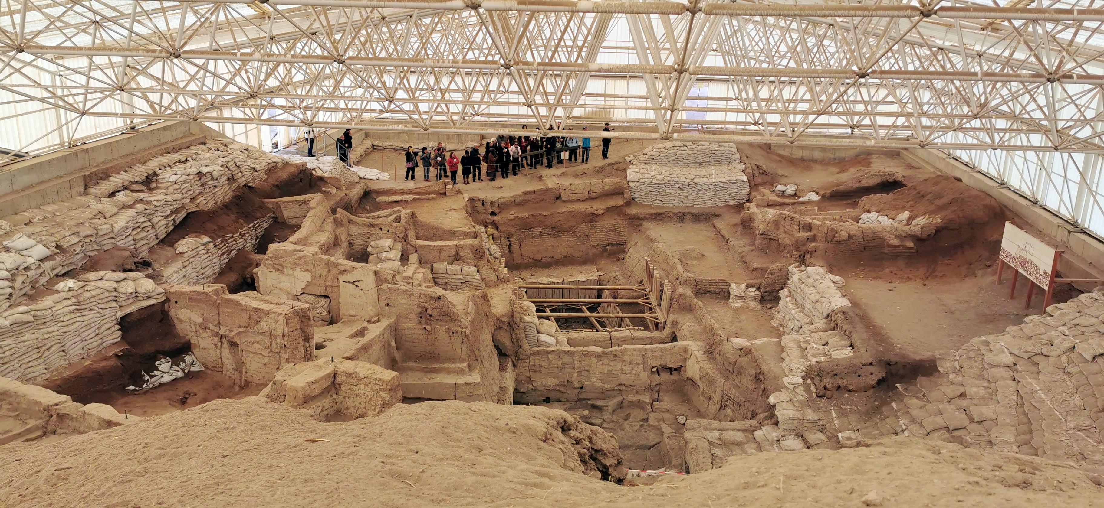
Çatalhöyük looks, to an uninitiated eye, like a low hill in a flat agricultural plain. Two mounds rise gently above the surrounding landscape of the Konya Basin in south-central Turkey, the larger reaching about 20 metres in height, the smaller somewhat lower, and if you did not know what lay beneath and within them you could walk past without a second glance. That indifference to surface appearance is precisely what makes the site so extraordinary when you do understand what it contains: one of the earliest and largest Neolithic settlements ever found, a proto-city that housed somewhere between 3,500 and 8,000 people from approximately 7500 to 5700 BCE, at a time when the concept of urban life was still being invented and most of the world's human population lived in small mobile groups.
The site is a tell, an artificial mound formed by the accumulated debris of thousands of years of continuous occupation, layer upon layer of mud-brick structures built, used, abandoned, partially demolished, and built over again across millennia. Within those layers are the preserved remains of hundreds of buildings, the wall paintings, plaster reliefs, animal installations, and burial deposits that have transformed archaeological understanding of Neolithic life. The buildings at Çatalhöyük had no ground-level doors: entry was through holes in the roofs, accessed by ladders. Houses were built directly against one another in a honeycomb arrangement with no streets between them, the rooftops serving as the primary public circulation space. The dead were buried beneath the floors of the houses in which people continued to live, the ancestors physically incorporated into the domestic space of the living.
The wall paintings discovered in the upper levels of the site are among the oldest known examples of landscape representation in human art, including what may be the earliest map ever made — a painting showing what appears to be a town plan with a volcano erupting behind it, a document of human spatial thinking from nine thousand years ago that remains remarkable for what it implies about the cognitive and social sophistication of the people who made it.
Historical Significance
Çatalhöyük matters because it is evidence that human beings were living in complex, densely settled, symbolically sophisticated communities at a much earlier point in prehistory than previously understood. When James Mellaart began excavating the site in the 1960s, the finds he uncovered — the painted walls, the sculptural installations, the evidence of organised communal life at a scale that had previously been associated only with the later Bronze Age — were sufficiently unexpected to transform the field of Neolithic archaeology and to generate a controversy, partly about the finds themselves and partly about Mellaart's working methods and honesty, that continued for decades.
The site provides irreplaceable evidence for the transition from nomadic hunter-gatherer life to settled agricultural community, a transition that is among the most consequential in the entire span of human history. The questions Çatalhöyük raises and partially answers about how that transition happened, what social structures it required and produced, how gender roles were organised in early settled communities, what symbolic and religious systems sustained collective life before writing, are questions that bear directly on understanding the origins of the world we live in today.
The site's evidence for remarkably egalitarian social organisation, at least in its early phases, with no evidence of significant social hierarchy in burial goods or house size, has made it an important reference point in debates about whether social inequality is an inevitable feature of complex settlement or a historically contingent development.
Threats and Risk Assessment
Climate and Environmental Deterioration
The most significant and poorly understood threat to Çatalhöyük is environmental. The site's extraordinary preservation owes much to the specific soil conditions and moisture regime of the Konya plain over the past several thousand years, conditions that are now changing as climate patterns shift. The mud-brick architecture and organic materials preserved within the tell — including wood, plant remains, textiles, and the painted plaster surfaces — are sensitive to changes in temperature and humidity that affect the chemical and biological processes acting on them. Rising temperatures and changing precipitation patterns in central Anatolia are altering those conditions in ways whose long-term consequences for the site are not yet fully understood.
Post-Excavation Deterioration
A challenge common to tells and other deeply stratified sites is that material exposed during excavation deteriorates more rapidly than material still within the tell. The painted walls and plaster surfaces that are Çatalhöyük's most significant finds are particularly vulnerable once exposed, and the management of excavated areas — providing appropriate shelter, controlling moisture and temperature, preventing biological growth — requires sustained resources and technical expertise that are not always consistently available.
Visitor Management
The site's World Heritage status has increased its visitor profile, and the balance between providing meaningful public access and protecting the fragile, partially excavated deposits is a continuing management challenge. Protective shelters have been constructed over key excavated areas, but the infrastructure required to manage visitors in a way that does not compromise the research environment or damage exposed deposits requires ongoing investment.
Funding and Research Continuity
Long-term archaeological research programmes of the scale and duration of the Çatalhöyük project are resource-intensive and dependent on sustained funding from multiple international sources. Interruptions to research continuity risk leaving excavated material inadequately documented or monitored, and the institutional knowledge embedded in long-running field projects is not easily reconstituted once dispersed.
Research and Scholarly Context
Çatalhöyük is one of the most intensively researched archaeological sites in the world, and the methodological standards developed there have influenced Neolithic archaeology globally. The site's research programme has pioneered the application of bioarchaeological analysis to questions of social organisation, using isotopic analysis of human remains to trace patterns of mobility, diet, and kinship that have fundamentally altered understanding of how Neolithic communities worked.
The evidence for relatively egalitarian social organisation at the site, at least in its earlier phases, has been particularly significant for debates about the social history of inequality. Analysis of burial goods and house sizes across multiple occupational phases shows little evidence of significant wealth differentiation, a finding that challenges assumptions about the inevitability of hierarchy in complex settlements and has implications well beyond Neolithic archaeology.
Research into the symbolic life of the community — including the wall paintings, animal installations, and the complex mortuary practices involving skull curation — has been approached through a careful combination of contextual analysis and theoretical frameworks drawn from anthropology and cognitive science.
If Nothing Changes
The threat to Çatalhöyük is not dramatic in character but is genuine in consequence. The site cannot be fully excavated; the tell contains more information than any programme of research could realistically extract, and the unexcavated portions represent an irreplaceable archive of early human life that responsible management is obliged to preserve for future researchers with analytical tools that do not yet exist. The environmental changes affecting the site are gradual but directional, and without sustained monitoring and adaptive management the conditions that have preserved the site's contents for nine thousand years will continue to change in ways that reduce what future research will be able to recover.
Çatalhöyük holds the earliest evidence of urban life as a human project, and the questions it can answer about how human beings first learned to live together in complex communities are questions that remain relevant to understanding what we are and how we got here. Sustaining the research programme, the monitoring infrastructure, and the institutional capacity to manage this site responsibly is not an archaeological luxury. It is an obligation to the future.
Historical Timeline
The First Settlement
People begin living on the site of what will become Çatalhöyük, in the wet, reed-fringed environment of the Konya plain. The earliest settlers are farming communities growing emmer wheat, einkorn, and barley, and herding cattle, sheep, and goats. The transition to settled life appears to have been rapid and confident rather than gradual and tentative.
The Great Period
Over more than a millennium, the settlement grows, is rebuilt, and grows again, accumulating the layers that will eventually form the East mound. Wall paintings become more elaborate, plaster installations more complex, and the symbolic programme of the interiors more developed. Cattle skulls and horns are installed in walls and on platforms. The treatment of human skulls — some plastered and painted and circulated between buildings — suggests mortuary practices of considerable elaboration.
The Transition
Settlement activity shifts partially to the West mound as conditions on the East mound change. The reasons for this shift, and for the eventual abandonment of the site around 5700 BCE, are not fully understood, though changes in the local hydrology and climate are likely contributing factors. The people who leave carry with them the cultural practices and knowledge developed over nearly two thousand years of settled life.
Mellaart's Excavations
British archaeologist James Mellaart begins excavating Çatalhöyük and produces a series of extraordinary discoveries, including painted walls, plaster reliefs, and figurines that attract enormous international attention. His interpretations prove influential and controversial in roughly equal measure. He is subsequently banned from excavating in Turkey following the Dorak Affair, a controversy involving allegedly smuggled artefacts that was never fully resolved.
The Stanford Excavations Begin
Ian Hodder of Stanford University leads a new phase of excavation at Çatalhöyük, applying contemporary archaeological methods including micromorphology, isotopic analysis, and systematic sampling. The new work produces a considerably more nuanced picture of Neolithic life at the site, challenging some of Mellaart's more speculative interpretations while confirming the fundamental evidence for a sophisticated, densely settled, symbolically rich Neolithic community.
UNESCO World Heritage Inscription
Çatalhöyük is inscribed on the World Heritage List, recognised for its outstanding universal value as evidence of Neolithic community life and as one of the best preserved and most extensively studied early human settlements in the world.
Related Heritage Sites

Baghdad
For five centuries the intellectual and political capital of the Islamic world — a city of libraries, hospitals, observatories, and markets that drew scholars, merchants, and diplomats from across Eurasia. At its Abbasid height it was, by most estimates, the largest city on earth. Its House of Wisdom preserved Greek philosophy, advanced mathematics and astronomy, and produced original work in medicine and optics that would not be surpassed in Europe for centuries. Very little of that city survives. What does survive is concentrated in four historic areas — Old Rusafa, Al-Karkh, Al-Adhamiya, and Al-Kadhimiya — containing 132 formally listed monuments within a fragile urban fabric now threatened by conflict damage, institutional failure, infrastructure collapse, and climate change.

Göbekli Tepe
The oldest known monumental religious architecture on earth, built by hunter-gatherers approximately 11,600 years ago — 7,000 years before Stonehenge — whose T-shaped limestone pillars decorated with high-relief animal carvings have rewritten the prehistory of human civilisation and forced a fundamental rethinking of the relationship between religion, social complexity, and the origins of agriculture.

Palmyra
A desert oasis city that became one of the most important cultural crossroads of the ancient world — a trading hub where Graeco-Roman, Persian, and Semitic civilisations met, fused, and produced an art and architecture of extraordinary distinctiveness. For two centuries the most significant trading city on the Silk Road between the Mediterranean and Mesopotamia, its ruins — colonnaded streets, a spectacular theatre, funerary towers, and the Temple of Bel — survived two millennia of desert isolation before suffering deliberate, systematic demolition by ISIL forces in 2015. The destruction, carried out over months and broadcast as propaganda, was one of the most devastating acts of cultural destruction of the twenty-first century. What remains is fragmented, unstable, and in need of conservation resources that have yet to materialise at the scale required.